The Abel Tasman Track: Explore this premier coastal walk.

Walk the length of the park on an easy to follow, well formed track. The scenery is simply stunning!

The Abel Tasman Track is roughly 60km long, winding its way from Mārahau in the south up to Wainui Bay to the north. The mild climate, golden beaches and lush native bush make it one of the most popular New Zealand Great Walks.


The track is the perfect way to explore the coastal beauty of the Abel Tasman National Park. An easy to moderate walk, the Abel Tasman track is well-formed and easy to follow, with regular signposts and markers along the way.

There are many Abel Tasman walks. As a coastal track it is easily accessible by boat which means you have the option to walk a section of the trail as a half day or full day walk, or the entire length over 3-5 days.

There are a number of DOC huts and campsites located along the Abel Tasman Coast Track, which provide basic accommodation and facilities for walkers. A Great Walk pass is required to stay in the huts, and reservations are essential during peak times.walk

Abel Tasman Coast Track Info

Track Distance: 60km
Walk Time: 3 to 5 days (for section details see below)
Activity Level: Easy to moderate
Kayaking times: Mārahau to Observation  3hrs
                              Mārahau to Anchorage    4hrs
                              Anchorage to Bark Bay    2hrs
                              Bark Bay to Onetahuti     1.5hrs

Highlights: Crystal clear water, golden sand beaches, lush native bush, New Zealand wildlife
Climate: Moderate, maritime with warm summers and cool winters. Learn more about Abel Tasman Seasons
What to bring: Visit our Abel Tasman Planning & Preparation guide
Where to stay: See our Abel Tasman Camping & Accommodation guide
Tidal Crossings:  Tide times at Awaroa Inlet must be checked carefully. The inlet may only be crossed within 1hr 30mins before and 2hrs after low tide so please make careful note of these times. Outside of these times the crossing is dangerous. There are other tidal crossings in the Park (Torrent Bay, Bark Bay) but all have alternate high tide routes. You can check the Abel Tasman tides here and check the weather in the Abel Tasman here

Plan & Prepare - Check the tides for your Abel Tasman track walk
Crossing the Awaroa tidal inlet

For people with even a modicum of physical fitness, the Abel Tasman Coast Track is a comfortable walk. This is not a trek through the wilderness where bush bashing, river crossings and complicated navigation is required. The track is well graded and while there are some steeper uphill sections, the gradient is gently undulating for the most part. As the track is situated along the coast with the huts and campsites located right on or beside the ocean, this makes a multi-day tramp along the track a combination of a tramp and a beach holiday. You walk or kayak for part of the day and then chill out and swim on the beach in the afternoons and early evenings. The track is well marked, well maintained and insanely easy to navigate which means you don’t really need outdoor experience to complete it. Of course this all means the Abel Tasman is a viable option for pretty much anyone, rather than just for people who are physically fit, have bushcraft and backcountry skills and own specialist outdoor equipment worth many hundreds of dollars.

Day Walks along the Abel Tasman Track 

Falls River - Cruise & Walk | Abel Tasman - An Abel Tasman Day Trip

Falls River

Walking & Hiking | Full Day
from $102
Return water taxi and walking trip: Water taxi to Torrent Bay, walk the scenic Abel Tasman Coast Track to Bark Bay (2.5hrs) crossing the Falls River Swingbridge.
Book Now

Bridge and Beach

Walking & Hiking | Full Day
from $103
Return water taxi and walk: Water taxi from Totaranui to Torrent Bay before walking through to Bark Bay. Water taxi back to Totaranui.
Book Now
Great for Families

Pitt Head Walk

Walking & Hiking | Half Day
from $96
Return water taxi and walking trip: Water taxi to Anchorage to walk the Pitt Head Loop Track (1.5hr) round trip.
Book Now

Heart of the Park

Walking & Hiking | Full Day
from $106
Return water taxi and walking trip: Water taxi to Torrent Bay, walk the scenic Abel Tasman Coast Track to Onetahuti (4hrs).
Book Now

Abel Tasman Classic

Walking & Hiking | Full Day
from $130
Return water taxi and walking trip: Water taxi the length of the Park to Totaranui and then back to Torrent Bay. Walk north to Bark Bay (2.5hrs).
Book Now

Awaroa Escape

Walking & Hiking | Full Day
from $114
Return water taxi and walking trip: Water taxi to Bark Bay or Onetahuti and then walk to Awaroa Bay (from Bark Bay 3hrs, Onetahuti 1hr).
Book Now

Detailed sections of the Track

Mārahau to Anchorage

Walk Time: 3 to 4 hrs
Distance: 12.4km
Side Trips: Tinline Nature Walk (Tinline Bay) – 20 mins return
                     Pitt Head loop  – 40 mins to 1 hr 30 mins

The southern entrance to the Abel Tasman Coast Track begins with a walkway over the tidal inlet. You’ll get wonderful views looking southwards back to Mārahau a short way along the track. Stu’s Lookout, located on a side track a few metres on the sea side of track, provides perhaps the best views back towards Marahau and also the beginning of the Astrolabe Roadstead to the north.

After you pass some thick bracken and low bush you will cross a short bridge to find yourself at Tinline Bay, and a clearing that is the first campsite in the Abel Tasman. This is perhaps the most under used campsite in the Park because it’s only about 3km into the Park and is located on a grassy clearing, not right on the beach like most of the other campsites. Tinline is a lovely little spot and it includes a short nature walk to the west of the clearing that is ideal for small children to explore.

The track rises to the north of Tinline for the best elevated view thus far as you look directly down into Coquille Bay, the first all-tide deep water bay in the Park. The native bush becomes taller from this point as the Track winds its way between bays like Apple Tree, Stillwell and Akerston which are all located down to the right a short distance from the main track. A longer walk off the track are Observation Beach and Watering Cove both of which look out towards Adele Island.

The track then drops down to Anchorage where the first DOC hut and a large campsite is located. Anchorage is the most visited beach in the Park, particularly by people catching water taxis from Marahau or Kaiteriteri for a day trip. Not part of the main Abel Tasman Track and, back towards the southern end of the Anchorage campsite, is a loop track that leads to Te Pukatea, many people’s favourite classic Abel Tasman crescent-shaped beach. The track also takes you to the end of Pitt Head and back along the cliff tops to Anchorage. Pitt Head has been extensively trapped for predators by the Abel Tasman Birdsong Trust over the past several years so features some of the best birdsong you will find anyway in the Park.

Anchorage to Torrent Bay

Low Tide Route:
Walk Time: 20 mins
Distance: 0.9 km
The low tide track to Torrent Bay scoots directly across the estuary from the northern end of the Anchorage beach. It’s only 900m but is only crossable, without the necessity to swim, during low tides.

High Tide Route:
Walk Time: 1 hr to 1 hr 30 mins
Distance: 0.9km
Side Trip: Cleopatra’s Pool 40 min return

The high tide track climbs out of Anchorage, up along the ridgeline and then drops down to a winding track beside the Torrent River estuary. The views across the estuary are stunning on full tides. This track also takes you past the side track to Cleopatra’s Pool, an incredible fresh water swimming hole with a natural waterslide that runs between smooth rocks. The track around the estuary is rocky in parts but only rugged enough to be vaguely adventurous for just about anybody.

Torrent Bay is the largest settlement of private dwellings in the Abel Tasman. It’s a lovely wee village but you’ll need to stick to the public track to make sure you don’t invoke the wrath of the local holiday home owners, many of which aren’t too keen on sharing their little slice of paradise from the proletariat. Torrent Bay also has a nice little sheltered DOC campsite.

Torrent Bay to Bark Bay

Walk Time: 2 to 3 hrs
Distance: 7.8 km
Side Trip: Falls River Falls 3 hrs return

After a short climb the Abel Tasman Track follows the ridgeline inland for a while but does offer wonderful views down to the bays below, particularly Frenchmans Bay. It then drops down to the Falls River which you cross by means of a wonderful swing bridge. For anybody not afraid of heights this will be a highlight. The views down Falls River are marvelous with the water reflecting the greens of the native bush that grow right down to the water’s edge.

A short distance after the bridge is a side track down to Sandfly Bay. Don’t let the name put you off, or the rock-hopping you need to complete to get down to the beach. Sandfly is a wonderful beach and the tidal inlet, particularly on a full tide, is absolutely stunning. The entrance to Falls River from the ocean sea is constantly changing its position from the northern end to the southern end of the beach and back again depending on the tides and storms. This creates sand spits and islands of golden sand with shallow lagoons in between.

Medland’s is the next beach which is viewable below from the track. Meddy’s is another natural dark green marvel lined with native bush and is the perfect place for a picnic. The trail from here provides elevated views across to Bark Bay which is only a few hundred metres further along the Track. Bark Bay has the second DOC hut available in the Abel Tasman and also has a good size campsite stretching along the narrow sandy cove between the sea and the tidal inlet behind.

Bark Bay is also home to a group of kākā which have recently been bred in captivity before being set wild. Kākā are large brown parrots native to New Zealand and possibly the smartest and most mischievous birds in the world. If you do encounter these birds please don’t feed them. Human food can be harmful to kākā and they are supposed to be learning how to feed themselves in the wild.

Bark Bay to Onetahuti

Walk Time: 2 hrs
Distance: 6.1 km

The low tide track from Bark Bay takes you directly across the estuary to the track north in a few minutes. The high tide track takes you around the back of the picturesque inlet and across a wonderful little bridge.

The track from here through to Onetahuti is sometimes gently and sometimes not so gently undulating. Before you know it though, you’ll descend and pop out at Tonga Quarry. In the early 1900s this was the site of some activity to quarry Separation Granite. In fact, some of this granite was used in Nelson to form the steps of the Cathedral. There is still some evidence of this quarrying including a few square shaped blocks of granite. While it might be marked as a campsite on some older maps, the Tonga campsite was closed after it was damaged in a storm which combined with a large tide.

After another short climb and walk along a ridgeline the long crescent shaped Onetahuti Beach comes into view. As you descend into Onetathuti, stop for a moment and take in the view. With the punga ferns in the foreground and the curve of the beach in the background this is also an ideal photo-op of the Abel Tasman Track.

Onetahuti to Awaroa

Walk Time: 2.5 hrs
Distance: 7.1 km

Onetahuti is a long beach so it takes about 15 minutes to get from the southern end to the walkway which takes you over the wetlands and on to the north. Depending on the status of the tide when you are walking along the beach you may have to either wade through Venture Creek or revisit your days as the Junior long-jump Champ of your youth.

Once you’re across the wonderful little walkway and bridge there is a short climb up to the ridgeline. Make sure you don’t just blast this out without stopping along the way to look back over your shoulder at the beach below. If this little climb does make you a bit custardy-tired, there is a seat towards the top for a wee sit down. There are nice bush views to the left (west) as you the track progresses and then an elevated view of the Awaroa Lodge below when you get along a kew kilometres. The Awaroa Lodge, open from the spring through to autumn, is a great place to stop for a coffee or a meal. If the weather is good, there is excellent pizza to be had and local craft ales at the more casual outdoor area just past the Lodge itself.

The DOC campsite and hut is a further 30 minutes along the Abel Tasman Track and around the estuary. This catches a lot of walkers out as they don’t realise there is a bit further to walk to their campsite.

Awaroa has a large inlet, some of which is lined with private holiday houses. The early attempts at farming and other enterprises many years ago are still much in evidence at Awaroa including an old steam engineer further along the estuary from the DOC campsite and even the site of an old school building.

Awaroa made headlines all over the world in 2016 when a couple of Kiwis decided to mount a crowdfunding campaign to buy a stretch of Awaroa beach that was put up for sale by its private owner. The fear was that the new owners could deny access to the beach for the New Zealand public, and access to our coast is something many Kiwis have strong feelings about. In a major triumph for people power, the New Zealand public donated over two million dollars, purchased the beach and ceded it into the national park. If you want to see this specific stretch of beach, head for the very end of the Awaroa Beach. Just be careful not to disturb the resident, land-nesting bird populations who will be particularly cranky during the breeding season.

Awaroa to Tōtaranui

Walk Time: 2 hrs 30 mins to 3 hrs
Distance: 7.1 km

Directly across the estuary from the Awaroa DOC hut and campsite, signaled by a round orange track marker is where the track continues north. The walk across the estuary is only possible 1.5 to 2 hours either side of low tide. There is no way to cross the estuary during higher tide unless you have a boat at your disposal.

The section of track on the Tōtaranui side of estuary starts with a wonderful section through wetlands featuring large ferns and other light green foliage. The Waiharakeke Bay campsite located a little along the track is one of the most underrated spots in the entire Park so worth a look around, even if you are not staying there. Shortly afterwards you will stumble out of the bush onto the beach at Goat Bay, another marvelous golden-sand beach which you walk along before resuming on the track.

You will need to steal yourself for a climb out of Goat Bay. Back in the day the track actually followed the coastline and was more gently undulating, but was extensively damaged in a storm a few years back and the new inland track was cut in its place. As you descend on the other side of the hill you’ll get incredible views of Tōtaranui.

Tōtaranui is another long, golden-sand beach, and the only part of the Abel Tasman Track that is accessible by road. There are tent sites located along the grassy verge beside the beach which are dedicated to the use of people walking the Abel Tasman Coast Track. Across the narrow gravel road from the beach is the main Tōtaranui camping ground. This is a large camping ground that is enormously popular during the Christmas and New Year peak season.

Tōtaranui to Whariwharangi

Walk Time: 3 hrs 30 mins
Distance: 7.5 km
Side Trip: Separation Point – 1 hr return
Gibbs Hill Track (Inland from Tōtaranui to Whariwharangi) 3 hrs

This section of the Abel Tasman Coast track is the most remote and receives the least visitors in the Park. Commercial operators in the Abel Tasman are not permitted to run scheduled services any further north than Tōtaranui so this limits visitor numbers to this northern tip of the Park.

The roadway that leads along the tree-lined gravel road into Tōtaranui also cuts right at the northern end where the track starts off through some grassy flat land. The initial climb after the grassy bit is mercifully short before descending into a gully and a short distance along to Anapai Bay which you walk along to access the track to the north. There is another climb here so the track offers elevated views of Anapai back to the south and then across to Mutton Cove once you are around the corner to the north.

After a scramble over some rocks you’ll find yourself at Mutton Cove, another wonderfully remote and often windswept beach. The track splits at the top of a short climb and you can either walk directly across to Whariwharangi or take a loop track to check out Separation Point. The extra distance to Separation Point is well worth it. As indicated by its name, Separation Point separates Tasman Bay from Golden Bay. The views of the cliffs on either side and down to the lighthouse are ruggedly beautiful. The rocky outcrop below is home to gannet and seal colonies.

Abel Tasman Coast Track Map

FAQ’s

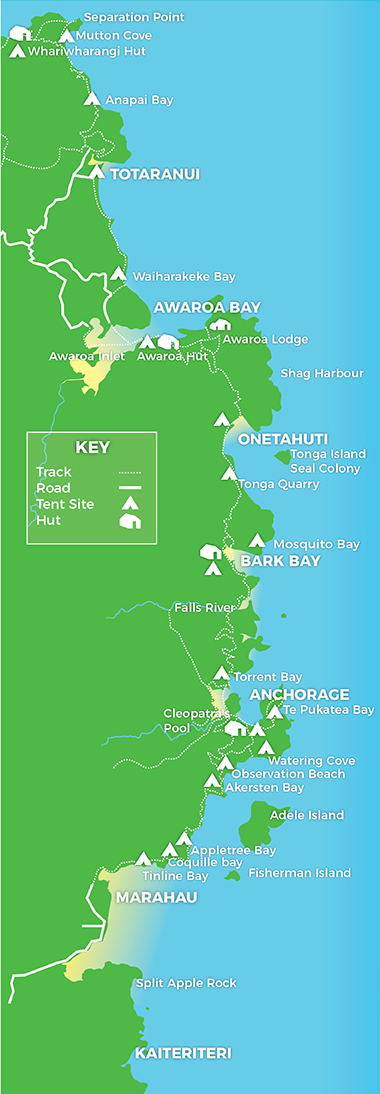
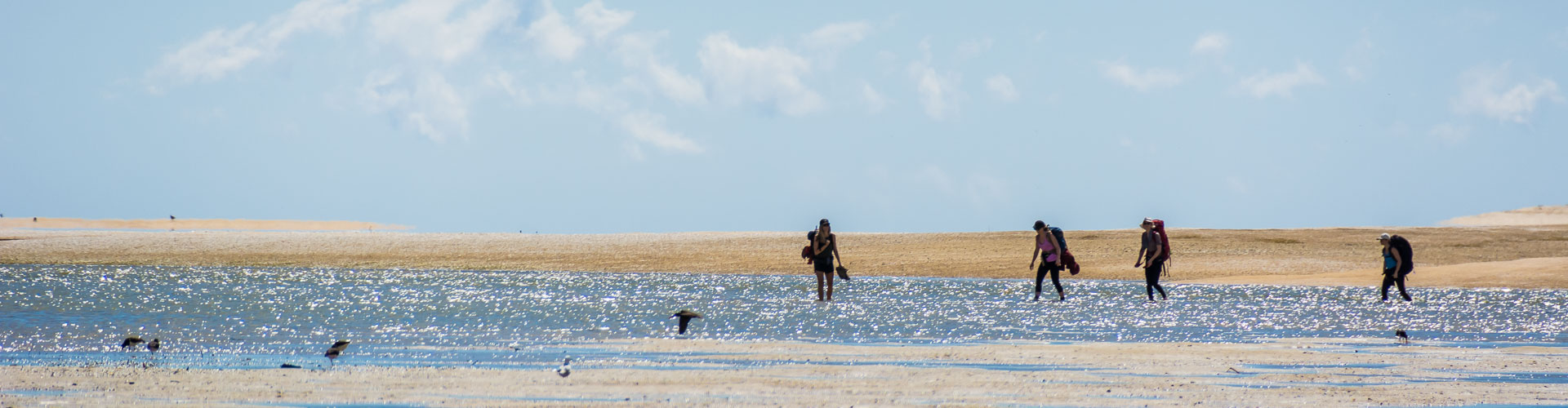
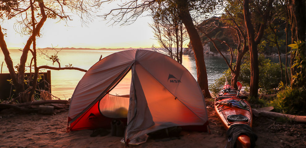
If you’re planning to walk the entire track – it can take anywhere between 3 and 5 days. The entire track from Marahau to Wainui bay is 60km long. There are various huts and camping spots along the way – see our camping and accommodation information

This is truly a difficult question. What we can tell you that perhaps the most popular section is the Tonga Quarry to Anchorage via Bark Bay and Torrent Bay (or vice versa). You can even do a day trip – jump on a  water taxi from Marahau or Kaiteriteri to Tonga Quarry (1.5 hours) and walk back to Anchorage to get the return taxi  (40 minutes). 

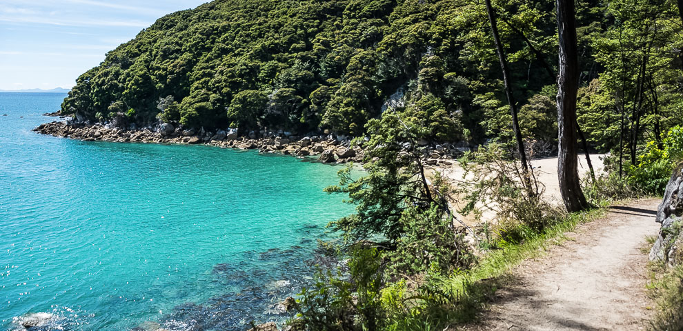
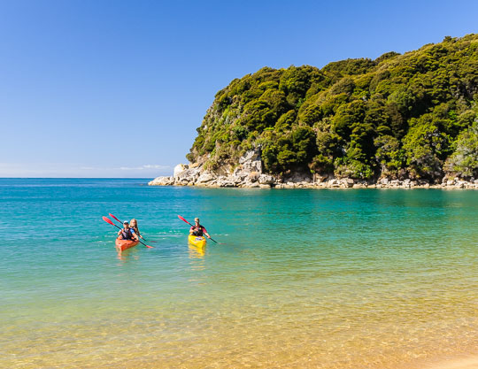
The Abel Tasman coast track is one of the easiest of all the New Zealand Great Walks. The climbs are not to strenuous and you can make your days as long or short as you like. Stretching the Abel Tasman walk out to five days gives you more time to relax on the beach or add a kayak trip to your agenda.

You can start or finish the walk from either end point – Marahau or Wainui Bay Read our section  How to get here for more information

Abel Tasman Track Map - Abel Tasman Walks - featuring Abel Tasman Coast Track Information Walk & Kayak times
Play Video

Proud to be a certified Zero Carbon  business

We offset 100% of our emissions, and make a contribution to local conservation projects on behalf of each customer. When you travel with us on a water taxi, you are helping to plant native trees, restore waterways, build climate resilience, and restore our biodiversity.

Find out more about our commitment and journey towards sustainable tourism

Learn about the  Environmental Access Fee (EAF) – the portion of your ticket price that goes directly towards preserving the unique environment you enjoy in the park.

Scroll to Top